Surveying & Geoinformation
The surveying team at DMT works all over the world, carrying out specialised and control measurement surveys for the infrastructure, tunnelling and mining sectors. Our clients benefit from our many years of experience and confident hand in developing our own surveying equipment and instruments. Our highly qualified team is happy to assist you in solving and executing even the most complicated surveying tasks, including:
- Determination of base grids
- High-precision terrestrial surveying
- Set up, review and refinement of project networks through GNSS measurements
- Consulting, design and development of concepts for complex survey tasks
- Accuracy forecasts for the selection of measuring equipment
- Control measurements
- Highest accuracy directional measurements
- Tacheometric surveys and traverse measurements
- 3D capture
- 3D calculations of mining subsidence, both static and dynamic
- Programming of databases with GIS user interfaces
- GPS measurements
- Tunnel orientation and surveying
- Determination of volumes and cross-sections
- Laser scanning & 3D models
- Satellite-based radar interferometry
Special-Purpose Surveying in Tunnelling and Pipe Driving
Our services in the field of tunnel construction and pipe driving cover 3D laser scanning surveys, independent control measurements with our high-precision gyroscopes DMT Gyromat 2000/3000/5000 and geodetic adjustment using recognised network adjustment programs. Having more than 50 Leica GNSS/GPS geo-systems and 10 gyro-measuring systems at our disposal, we are always able to deliver the most modern equipment suitable for your gyro tunnel measurement needs, and guarantee the high quality of measuring expected by regularly maintaining and carefully calibrating the equipment.
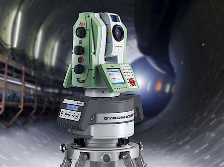
Gyromat 5000 measurement instrument for large-scale tunnel DMT Group
DMT's GYROMAT 5000 is the most accurate precision-surveying gyroscope in the world.
It has an accuracy of 0.8/1000 Gon (2 arc seconds) and comes with a host of special features, making it the ideal measurement instrument for large-scale tunnel and route surveying projects and other high precision alignment tasks e.g. in shipbuilding or further metrological applications.
Special-Purpose Underground Surveying in Mining
We are also qualified to deal with complex tasks and procedures in the area of special-purpose underground surveying:
- Carrying out orientation measurement
- Dielectric measurement
- Shaft surveying
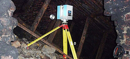
- 3D laser scanning to analyse performance & create a 3D model
- Monitoring
For example we calculate the complete reorientation of mines with a connection to the surface surveying grid by means of high-precision transfer of coordinates, scans, measurements and orientation from the base grid through mine shafts of up to any depth.
With our one-of-a-kind kinematic shaft surveying systems we carry out geometric as well as photo-realistic documentation of shafts fast, safely and with utmost accuracy. Additionally we conduct surveys for mapping of non-accessible cavities, such as those found in abandoned mine workings or in karst areas, using specially developed borehole scanners. When it comes to detecting movements of the ground surface or slopes over extensive areas, we also offer satellite-based and terrestrial radar interferometry services. An added benefit is the deployment of our specially designed radar interferometers for use in opencast mines, ideal for monitoring the stability of any sloping surfaces.
Safety is Key for Surveying & Laser Scanning
The safety factor plays a major role within our range of services. Thus DMT's portfolio also boasts specialist measuring devices for use in hazardous areas, which meet the highest security requirements according to ATEX. For the measurement and monitoring of offshore platforms and chemical plants, where the risk of explosion is equally high, we offer a system of intrinsically safe GNSS receivers and antennas, again ensuring that ultra-high-precision monitoring of motion is performed in compliance with all safety regulations.
Moreover we offer an explosion proof ZF laser scanner for 3D laser scanning of underground mines and cavities deemed critical with regard to safety.
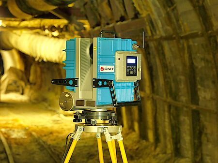
IMAGER 5006EX - Ex-proof Laser Scanner
With a long history in the field of mine safety, DMT is proud to have developed the world's only ATEX approved 3D laser scanner specially designed for explosive atmospheres together with our partners at electrical engineering company Zoller+Froehlich GmbH.
Geoinformation: GIS technologies and geo information
The results from measurement, geological and geophysical surveys together with thematic maps and remote sensing data are compiled to create a uniform geodetic basis for evaluation.
Both spatial and non-spatial data can be migrated, modelled, harmonised, and can be re-processed, and the import, analysis, transformation and visualisation of over 300 different data sources, such as GIS and CAD-data formats, web services, raster data and various databases can be realised.
DMT offers the full service, from programming and set-up to operation of GIS software and systems aligned to handle your specific geo data and the issues of your project:
- Desktop version in the local network
- Mobile application
- Web-based GIS application
DMT also provides a range of system support and hosting for public or internal geoportals. The performance of your web applications and the safe storage of your data is guaranteed by a state-of-the-art server architecture based on the ArcGIS server in the TÜV NORD data center.
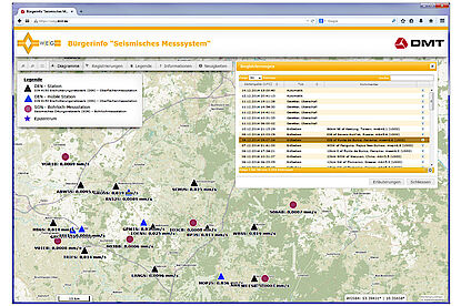
To complement the GIS services and build a complex monitoring and warning system, DMT offers its very own software, DMT SAFEGUARD. This database-supported system is designed for the administration, analysis and online display of all your monitoring data. Our geomatics experts will be happy to advise you on our GIS solutions.
Please feel free to contact our specialists.
Contact us
- Dr Ralf Fritschen
- exploration(at)dmt-group.LÖSCHEN.com
- Contact form
Links
Watch our shaft scanning on YouTube


